
Executive Summary:
- A potential tropical depression may hit the Philippines this week, between May 24 and 25. As of this time, the potential tropical depression will not directly make landfall in Metro Manila.
- PAGASA reported that as of 8 AM, May 22, a low pressure area (LPA) has formed 1,255 kilometers East of Southeastern Mindanao, outside the Philippine Area of Responsibility (PAR).
- According to PAGASA’s forecast, the LPA may enter PAR by tonight or tomorrow morning, May 23. Depending on its trajectory, it may make landfall over the Bicol Region-Eastern Visayas by late Friday, May 24 or Saturday, May 25.
- PAGASA also says that the LPA may develop into a tropical depression between Friday, May 24 to Monday, May 27, depending on its track.
- From today, May 22 to Sunday, May 26, the LPA is expected to affect eastern sections of the country, particularly Eastern Visayas, the Bicol Region, and including Southern Luzon, bringing scattered rain showers and thunderstorms in the area.
- Scattered rain showers and thunderstorms can cause landslides and flash floods in directly affected areas. The rest of the country may also experience isolated thunderstorms and rain showers, especially during the afternoon and evening.
As of 8 AM today, May 22, a low pressure area (LPA) has been monitored by the Philippine Atmospheric, Geophysical, and Astronomical Services Administration (PAGASA) at 1,255 kilometers East of Southeastern Mindanao, outside the Philippine Area of Responsibility (PAR).
If the LPA develops into a tropical depression, it will be named “Aghon,” the first for the year 2024. As of writing, from today, May 22 until Sunday, May 26, PAGASA expects the LPA to affect the eastern sections of the country, particularly Eastern Visayas and the Bicol Region, bringing scattered rain showers and thunderstorms in the area. These rains and thunderstorms may cause landslides and flash floods in directly affected areas.
Towards the end of the week, the trough of the LPA may also affect Southern Luzon. The rest of the country may also experience isolated thunderstorms and rain showers, especially during the afternoon and evening.
In a climate briefing done by PAGASA at 9 AM today, two possible scenarios on the trajectory of the LPA have been presented:
| SCENARIO (No. 1) | ALTERNATE SCENARIO (No. 2) |
|---|---|
| Entering PAR: The LPA may enter PAR by tonight, or tomorrow morning, May 23. | Recurving and developing into a tropical depression: Alternatively, the LPA may remain offshore and recurve over the Philippine Sea near Bicol Region-Eastern Visayas and develop into a tropical depression by Friday, May 24 or Saturday, May 25. |
| Making a landfall: By late Friday, May 24 or Saturday, May 25, it may make a “landfall” over the eastern section of the country, particularly, Bicol-Region-Eastern Visayas. | |
| Developing into a tropical depression: It may emerge over the waters of East Luzon afterwards, and may develop into a tropical depression by Sunday, May 26 or Monday, May 27. |
Please see the map of the LPA’s two possible trajectories from PAGASA:
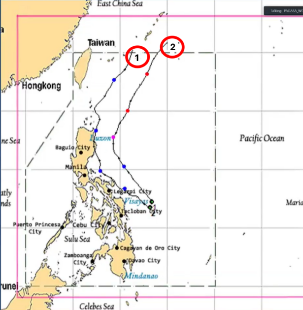
Source: PAGASA Briefing, May 22, 2024
According to PAGASA, the following weather conditions shall prevail over the next few days amid the LPA:
May 22 (Wednesday) to May 23 (Thursday)
- Generally fair weather conditions over the country with higher chances of thunderstorms, especially in the afternoon and evening.
May 24 (Friday)
- Generally fair weather conditions over most parts of the country with the possibility of the usual isolated rain showers and thunderstorms in the afternoon or evening chances of thunderstorms, especially in the afternoon and evening.
- The LPA may bring scattered rain showers and thunderstorms in the Bicol Region and Eastern Visayas.
May 25 to 26 (Saturday to Sunday)
- The trough of the LPA (which may develop into a tropical depression) may bring scattered rain showers over the eastern portion of Southern Luzon and Eastern Visayas which may trigger flash floods and landslides.
- The rest of the country may continue to experience isolated rain showers or thunderstorms.
Clients with travel plans are advised to confirm with their respective service providers for any possible flight or ferry booking cancellations.
PSA will continue to monitor developments and advise clients as warranted.